Yesterday, we abandoned our lake front path to test the new garmin along the streets. I forgot how much I love doing this....running until you hit a light and then turning so you don't have to stop. So how did Garmin do?
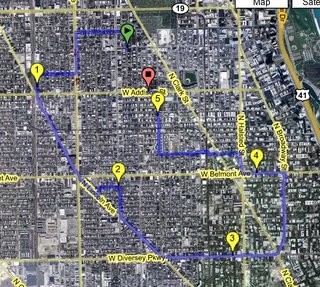
 Good! You can see in the picture (if you click on it, the link will take you to favoriterun.com and you can zoom in. It does get a little jaggedy in some places and I had a lot of problems in the last mile keeping the signal. However, I have now added the gps sattelite accuracy to the data fields on the main part of the watch so I can see what's up during the run. I might not have had a great signal in the first place because it took awhile to get and then as soon as it had it, I was moving. I guess the idea is to leave it sitting still for awhile while you stretch etc etc.
I also was seeing some really really funny behavior in the elevation part of the data when I uploaded it to MotionBased. I am guessing I didn't ascent 2000 feet, nor is it likely that I descented 2000 feet. It was counting all the little up and downs the signal was getting and adding it all up and making it look like I was running over some kind of mountainous country (chicago=flat).
 I then found in MotionBased, if you are looking at an activity, in the upper right hand corner there is a button that says Activity Options. If you click there, there is something called MB Gravity Elevation. Apparently this compares your data with a governmental database of elevations and then compares your position at ABCD.....and so on and compares each point to what your elevation should be. I did this and I got a nice flat line which is what I would expect. It also has us at 600ft, which is about where Chicago is about sea level. Excellent.
 So the run stats. Felt good, wanted to slightly slow down a bit yesterday since we are racing
 tomorrow (wtf...racing tomorrow...not quite read). It was really fun to just run through the neighborhood and not be thinking about remembering where we went because I just came home, plugged in the watch and viola, the map is drawn. I am going to use the watch in the race tomorrow, maybe I'll try the virtual partner deal...hmm..
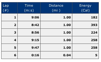
I have a question and I know that Bob had issues with this at first. Here it says that my distance was 5.04 miles (similar to what the watch says). but then MB recalculates it to be 5.21 miles....why doesn't it fix the laps also? Thanks!
Oh yeah, I also had this idea to drive the Chicago marathon course with the watch before the race and then put a little virtual partner on there running the course at an 8:25 pace....you could even program in where the water stops are so that it would tell you how far away from gatorade/water or whatever. I then noticed here that MB has already programmed this! Check it out here and have fun!
12 comments:
I don't know why MB does not correct splits, maybe because not all use 1 mile splits, just guessing. SportTracks does correct splits to match the "cleaned up" data, however SportTracks does not correct elevation. Maybe they will work on that. Regardless, glad you are having fun with the new toy.
It is really important with the new chip to let it Lock on well before you start. I have only had one run with reception problems and it was for this reason. I have a routine now. Watch off the wrist looking at the sky as I lightly stretch for a couple of minutes. Then on the wrist and go, it works great.
Yeah we want to get SportTracks working (I don't really need to worry about elevation :-) ) but we are having windows verions issue...go figure. How did this operating system become so popular. grumble....oh well, i'm sure we'll get it soon.
You're going to use the virtual partner in the race tomorrow? Hehe. Why don't you try to catch the real partners in front of you!
Hmm...come to think of it, I don't think there will be many people in front of you tomorrow...you're too fast! So maybe you should use the virtual partner thingy after all.
I think I would really like one of those things. I just have no idea which one to purchase?!
joe-
I was just thinking the virutal partner as in, ok i want to run the 12K in 60 minutes...then I can just look down from time to time and see how I am doing on that goal. Also don't know how fast this race will be...still somewhat recovering from the 1/2 marathon. Just something fun to do and get a visit in to jason's folks. As far as the marathon..I don't know. I'm going to have to be pretty consistant with my splits to make the 3:40...might be nice to have something to look at while I am bored looking at the head in front of me at mile 17 :-)
Rabbit-
I would go with either the 205 or 305. In general they get much better reception...although the 201/301 have come down in price due to the new models....
BTW, good luck in the race tomorrow. I expect you two super stars to be at or near the front of the pack! Bring home the gold for Joey! (No pressure...)
Thanks joe....susan...the garmin is spectacular. I think you need one ;-)
The satellite feature is cool. I was able to zoom in on my old house. I kinda felt like Chloe on '24'...ok, only for a second
I'm still a novice at running and all the tracking technology available for it. Almost everything I've read on the various local running blogs seems to diss the MotionBased in terms of accuracy. Can someone tell me: Is it worth it to sign up and use this tool?
What am I missing if I just use the software that came with my ForeRunner?
All I have to say is you are way to way tech for me but what fun!
josh-
i think motion based corrects the data that comes out of the watch so it's a bit more accurate (???) i actually have no idea. I see a big difference between what the watch says and what MB says....I don't know if MB is correcting the data for elevation or what...but i like that it says i run farther :-) We'll see how the two systems due tomorrw after the 12K.
Hey! It's really neat to see your route in sweet home Chicago! What a hoot. Enjoy the watch...KEEP the WATCH! No Really, keep it!
DAd/Scott
Post a Comment